
Simpang Mengayau - Tip of Borneo
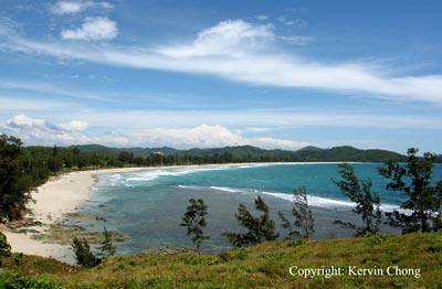
One of the beautiful stretches of azure blue water and pearl white sanded beaches seen from the stop over point.
Someone once quoted that the joy of travel lies in the journey and what it takes to get there rather than the destination. Well that someone most probably must be referring to Simpang Mengayau because the journey itself is an adventure in itself but the end point is no push over though as you will be richly rewarded when you finally set foot at the northern most point of the island of Borneo. Situated at least 30 minutes from Kudat, it is veritably an isolated cove with fantastic rock formations, idealic beaches and fantastic vistas. Though who are planning to venture to this destination better be prepared to have a four wheel drive vehicle or at least a car which suspension you don't mind saying bye-bye to later after your return journey. Far from being accesable the path leading to Simpang Mengayau only stretches for 10km of paved road while the last 6km of the way one must pass through a winding, bumpy and often butt aching dirt tract. Needless to say travellers are advised to go during the dry season as the stretch can be quite trecherous after rain storms when the road turns muddy and slippery. You will be passing through various villages and forested area as you make your way there, stopovers are non existant at this stretch of journey though at times some villagers do prop makeshift huts to sell wares like home grown vegetables and seashells.
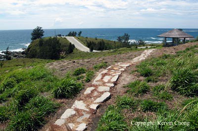
Stone pathway leading to the northern point.
Once you reach the end you can relax a bit as there is a small canteen selling food and drinks. There is also a small resort in kind which offers overnight stay in a traditional Murut longhouse if one is so inclined a little off the way before reaching the end. Travellers can also opt to take a few hours to swim in the clear waters of the beach or have a nice picnic out in the shadded coast. The main attraction awaits at the end though and most will often head there without pause. There is little in the way of shade here and after aligning from your vehicle there is still about 200 meters of walking distance to the rocky outcrop and this you'll have to do on foot. Various wooden huts are situated near the parking lot for those wanting to enjoy the coastal vista which the elevated ground offers.
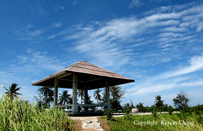
One of several huts for people wanting to rest or have a break facing the coastal sea.
The way is nicely paved and there is more than enough walking space to accomodate a large crowd so that one will still feel the vast empty space that seem to just strech from miles away. The breeze here is strong and offers some modicum of relief even when the sun is scorching heavily. Along the way you can stop at several lookout spot to view the great coastline, often with beautiful rock outcrops and gentle conifer trees. There is no other vistas like it anywhere nearby. Many offer beautiful spot for a commemorative photo shoot which a lot of people I observed do take advantage of.
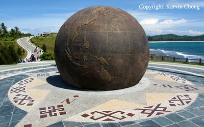
The large bronze globe denoting the site as the northern most point in Borneo.
You'll know that you are almost at the main attraction when you spot the large globe and compass, Here too is a great photo opt with one face describing Simpang Mengayau as the most northern tip of Borneo and the reverse with a small map of Southeast Asia with a large marker saying 'You are Here!'. But other than that there is not much to linger for, for your information this place often play hosts for the Kota Kinabalu Symphony Ochestra for the annual evening concert held here, details can be obtained from the Sabah Tourism Website. Moving on you will reach the climax of your trip.
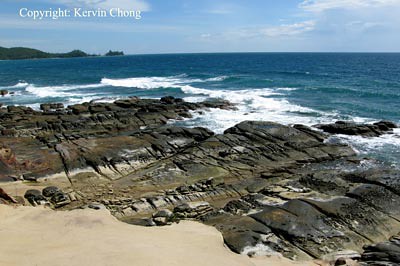
The folded effect of various rock layers caused by geologic forces are quite common along the peninsula.
The apex of the peninsular is a grand rocky outcrop of mostly obsidian rock with fringing sandstone. One a particular good day most of it will lie exposed as waves upon waves crash into it. Though people are often discouraged to venture down and a sign delivers this message clearly, it seems curiosity, adventurism, defiance or stupidity often cause certain people to try and climb down anyway to truly stand at the edge of the continent. This can be a bit dangerous as the rocks are often slippery and the fast incoming tides are unpredictable at best so the danger is real for one to slip and be swept off.
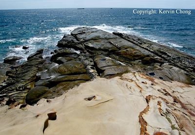
The apex of the peninsular is a large rocky outcrop of obsidian rocks.
From here one can stare out into oblivion and the vast stretching horizon without obstruction and it is truly a magnificent sight. To the right of the outcrop is a shallow seaflat with tiny islets bespeckling the azure bay and a single lighthouse built on a small outcrop in the middle of the ocean. Linear rocky outcrops are also present and makes a nice study in geometric patterns. Well that is most what you'll get if you decide to travel here and after all that sighseeing one can opt to take in a local specialty, burnt coconut or fresh coconut water straight from the trees. Other avenues to explore are the town of Kudat with fresh and cheap seafood.
![]()


No comments:
Post a Comment